Oddsconsin 59 and 60 explored several historic lime kiln ruins in the southeast of the state. Today, we focus on the Western Lime and Cement Company ruins in High Cliff State Park (Calumet County). The park is a Department of Natural Resources (DNR) property and the kilns are easily accessed by road from the park office. However, they lie behind a chain link fence due to their advanced state of decay. [1][2]
The site includes three kilns, a chimney and the shell of a two-story building. A photograph in a DNR publication shows the complex in 1905, when the kilns were connected to the building by a wooden enclosure. [3] The photograph is labeled “Copper Shop” – probably a misspelling of “Cooper Shop” where barrels were made to store and ship the lime. The wooden enclosure would have protected the lime from the elements and kept it dry. The photo shows a conveyor system for loading stone into the tops of the kilns and a railroad spur running next to the complex.
Near the surviving chimney, the photo shows a multistory building topped with what looks like a bucket elevator, similar to the “grain legs” seen on agricultural silos. Perhaps lime was conveyed via the elevator to be stored in the building. The chimney suggests a power source such as a boiler.
The High Cliff kilns were established in 1856 and went through several owners, including Western Lime and Cement, which also owned other kilns in the area. At its peak, the High Cliff plant produced as much as 500 barrels of lime per day, each barrel holding 200 pounds. [3] Western operated the facility into the 1930s, when it was acquired by Graymont, a lime manufacturer that is still in operation in Wisconsin. [4] The kilns were shut down in 1956.
The lime plant sits on a ledge overlooking Lake Winnebago. Kiln waste was dumped over the ledge and the rubble is still visible today. On historic air photos from the 1930s to 1950s, the kiln complex is clearly evident. [5] Later photos show that it quickly dissolved into the ruin we see today. [6] The limestone quarry, up the cliffs to the east, can be seen on Google Maps imagery. The quarry area is still only sparsely vegetated. Western Lime and Cement cleared the trees from the area, both to get at the limestone underneath and to provide fuel for the kilns and wood for barrels. [3]
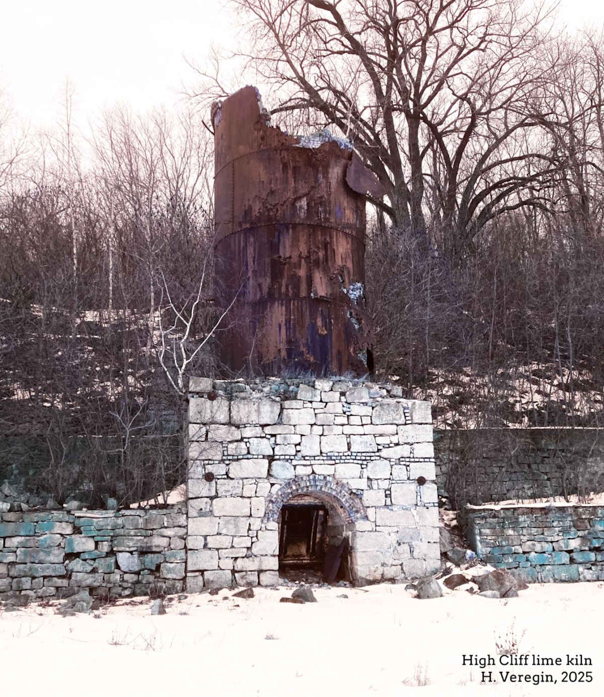
Of the kiln sites we have explored, this one especially evokes ghostly echoes of the past. The kilns are crumbling, the wooden buildings are long gone and the whole effect is one of decay. On the central kiln, the stone walls have almost completely fallen away to reveal a rusty iron inner chimney, its sections riveted together like an old steamship hull. The ragged top of the chimney exposes a liner of crumbling fire brick. Trees grow out of the cracks in the stone at the kiln base, where a draw pit gapes like an open mouth. It’s hard to imagine that this much deterioration has occurred in only seventy years.
You might wonder who first conceived of the idea of producing lime by heating crushed limestone. Archaeological evidence indicates that lime kilns have been in use since Roman times. Kiln ruins over two thousand years old have been found in Britain, France, Germany and Portugal. [7] The earliest kilns were relatively small stone structures in which limestone (and sometimes marble, which is also rich in calcium carbonate) was layered with wood and then burned to produce lime (mixed with the ashes from the burned fuel).
In the US Midwest, the earliest European settlers produced lime using crude stone kilns, which were sometimes temporary as the need for lime arose. [8] It wasn’t until the middle of the nineteenth century that the elaborate kilns and associated infrastructure like those we see at High Cliff were first developed.
Lime continues to be produced today in many parts of the US, but the scale of modern lime plants is orders of magnitude larger than at old sites like High Cliff. Wisconsin lime plants include the Carmeuse facility just north of the City of Manitowoc and plants owned by Graymont (once the owners of the High Cliff kilns) in Fond du Lac County, Green Bay (where the main kilns have been idled since 2017) and Superior. [9-12]
Graymont produces a wide range of lime products for various applications, including “baghouse” lime, dolomitic lime kiln dust, high-calcium hydrated lime, quicklime blends, “aerolime,” cement lime blends, calcium carbonate powder and many others. While the technology has become more sophisticated, the basic principle of lime production hasn’t changed much since the High Cliff days. [13]
Since European settlers first arrived in Wisconsin, aggressive resource exploitation has been a recurring theme. The logging industry is a well known example. The forests of northern Wisconsin are still recovering from the clear cutting that started in the late nineteenth century. Lead and iron ore mining likewise went through a similar boom-bust cycle, where production first exploded and then waned as the supply of easily obtainable ore was exhausted. [14][15]
Lime production followed the same pattern. The High Cliff kilns survived longer than many of the other operations we’ve looked at, most of which had stopped producing lime by the 1920s if not earlier. A century ago, lime production depended on local, cheap supplies of limestone and fuel. Once these were depleted, plants were no longer able to turn a profit, and they shut down, eventually fossilizing into the ruins we see today.
Sources and Notes
[1] Department of Natural Resources, High Cliff State Park. https://dnr.wisconsin.gov/topic/parks/highcliff
[2] Department of Natural Resources, High Cliff State Park Map. https://widnr.widen.net/s/nfjlgzg9w6/high-cliff_trail-map
[3] Department of Natural Resources, Lime Industry at High Cliff. https://widnr.widen.net/s/jdbrx2tmxs/high-cliff_lime-industry
[4] Daniel Seurer, Marblehead Wisconsin: 150 years of Lime operations in Fond du Lac County. https://danseurer.com/blog/2020/12/24/marblehead-wisconsin-150-years-of-lime-operations-in-fond-du-lac-county
[5] Wisconsin Historic Aerial Image Finder, https://maps.sco.wisc.edu/whaifinder, Photo 2H-144 (10/16/1953).
[5] Wisconsin Historic Aerial Image Finder, https://maps.sco.wisc.edu/whaifinder, Photo WROC Sherwood SE (03/13/2018).
[7] Maria Margalha et al., Traditional lime kilns - Industry or archaeology? https://www.researchgate.net/profile/Jorge-Brito-13/publication/283324537_Traditional_Lime_kilns_-_Industry_or_Archeology/links/5633723908ae88cf81ba4109/Traditional-Lime-kilns-Industry-or-Archeology.pdf
[8] W. S. Blatchley, 1903. The Lime Industry in Indiana (Report of the State Geologist). https://scholarworks.iu.edu/iuswrrest/api/core/bitstreams/8f838493-9c75-4a7c-8ffc-6e25c4cf2c51/content
[9] Manitowoc plant. Enter these coordinates in the Google Maps search bar: 44.168470, -87.700321
[10] Fond du Lac County plant. Enter these coordinates in the Google Maps search bar: 43.704459, -88.386543
[11] Green Bay plant. Enter these coordinates in the Google Maps search bar: 44.523798, -88.013615
[12] Superior plant. Enter these coordinates in the Google Maps search bar: 46.729340, -92.075439
[13] National Lime Association. https://www.lime.org/
[14] Wisconsin Historic Society, Lead Mining in Southern Wisconsin. https://www.wisconsinhistory.org/Records/Article/CS408
[14] Wisconsin Historic Society, Mining in Northern Wisconsin. https://www.wisconsinhistory.org/Records/Article/CS410