This is the second part in a series on Wisconsin’s state boundaries. Last week, Oddsconsin 50 looked at the Wisconsin-Illinois boundary. This week, we focus on the boundary with Minnesota.
The Wisconsin-Minnesota boundary starts in Lake Superior, travels a few miles up the St. Louis River, turns due south in a straight line to the St. Croix River, follows the St. Croix to the Mississippi River, and then follows the Mississippi to the Illinois boundary. The last leg of the Mississippi River boundary is with Iowa, not Minnesota.
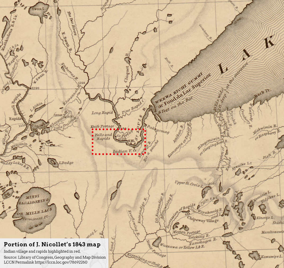
Let’s look at the St. Louis River portion first. Article II of the Wisconsin Constitution [1] states that the boundary runs up the main channel of the river “to the first rapids in the same, above the Indian village, according to Nicollet’s map.”
The reference to Nicollet’s map seems a bit vague given its significance for Wisconsin’s boundary. First off, who was Nicollet? And second, what map is the constitution referring to? The title and date of the map are not provided. Did Nicollet make only one map?
Historians agree that the constitution is referring to Joseph Nicollet (1786-1843), a French astronomer, explorer and cartographer who surveyed the upper Mississippi region in the 1830s. This appears to have been a vocation he chose for himself, although he did have both private and government sponsors. The reference in the constitution probably points to his magnum opus, his 1843 map titled, Hydrographical Basin of the Upper Mississippi River. [2]
This map covers the upper Midwest from Wisconsin all the way to the Dakotas, and as far south as Missouri. The map’s depiction of northwest Wisconsin (see the image accompanying this post) is based on observations made by Nicollet during his 1836-37 expedition. Clearly visible, on the south bank of the St. Louis River in present-day Douglas County, is the Indian village referenced in the constitution. Across the river is a Trading House (marked with the initials “T.H.”) and an asterisk indicating that astronomical observations were taken at this location.
A convenient spot, perhaps, but a bit imprecise as far as marking the location where the boundary takes a 90-degree turn. Where, exactly, does the first rapids on the St. Louis River begin? Perhaps that’s why the straight-line section of the Wisconsin-Minnesota boundary, which runs from the rapids on the St. Louis River “due south to the main branch of the river St. Croix” is not where it is supposed to be.
This straight-line section of the boundary is aligned to the state’s Public Land Survey System (PLSS), or at least, it’s supposed to be. The PLSS is based on a framework of townships – six-mile by six-mile squares of land – arranged in a checkerboard pattern across the state. Township locations were established in a mammoth surveying effort led by the General Land Office, in which survey crews traversed the state and placed monuments – often just wooden posts – at the locations they determined to be township corners. It took over thirty years – from the 1830s to the 1860s – to complete the work in Wisconsin. [3]
Why was this effort undertaken? To divide the state into bite-sized pieces to facilitate the orderly acquisition of property by private citizens.
Every township in the state has a Range Number, which indicates the location of the township east or west of the 4th Principal Meridian, which runs through the western part of the state. For example, townships in Range 15 West are fifteen townships west – about 90 miles – of the Principal Meridian. [4]
In northwest Wisconsin, the dividing line between townships in Ranges 15 and 16 was intended to be the location of the Wisconsin-Minnesota boundary. [5] Using township lines for political boundaries was common practice at the time, and many of Wisconsin’s county boundaries are also based on this principle. [6]
However, the boundary line, as surveyed by the General Land Office in 1852, runs through the interior of the townships in Range 15, shortchanging the Towns of Superior, Summit and Dairyland in Douglas County and the Town of Blaine in Burnett County. You could argue that about twenty square miles of land currently in Minnesota actually belongs to Wisconsin.
This problem was identified early on but never corrected. In 1929, Wisconsin allocated funds to have the line reestablished by a Wisconsin-Minnesota survey team, but Minnesota took no action. [5] Perhaps the vagueness of the location of the rapids on Nicollet’s map is part of the reason for this mistake.
But why was this location selected as the northwest corner of Wisconsin in the first place? The answer is that it wasn’t! To find out why, tune in next week to Oddsconsin 52.
Want Oddsconsin delivered right to your inbox? Subscribe here.
Sources and Notes
[1] Wisconsin Constitution. https://docs.legis.wisconsin.gov/constitution/wi_unannotated
[2] Library of Congress, Hydrographical basin of the upper Mississippi River from astronomical and barometrical observations, surveys, and information. https://www.loc.gov/item/78692260
[3] H. Veregin, Oddsconsin 12 – Point of Beginning. https://howard-veregin.com/blog/oddsconsin-12-the-point-of-beginning-oddsconsin-where-we-explore
[4] Wisconsin Geological and Natural History Survey, Wisconsin Township and Range Reference Map. https://wgnhs.wisc.edu/catalog/publication/000915
[5] Wisconsin Historical Records Survey, Origin and Legislative History of County Boundaries in Wisconsin. Madison, WI, 1942.
[6] H. Veregin, How Wisconsin’s Counties Got Their Shapes, Wisconsin State Cartographer’s Office. https://www.sco.wisc.edu/2021/05/04/how-wisconsins-counties-got-their-shapes/