Oddsconsin...where we explore peculiar and sometimes mysterious features of Wisconsin’s human landscape.
The term “Point of Beginning” seems to convey something vaguely mystical. Is it the starting point for a religious pilgrimage? Or maybe it relates to cosmology. Perhaps it's the gravitational singularity associated with the Big Bang and the creation of the universe?
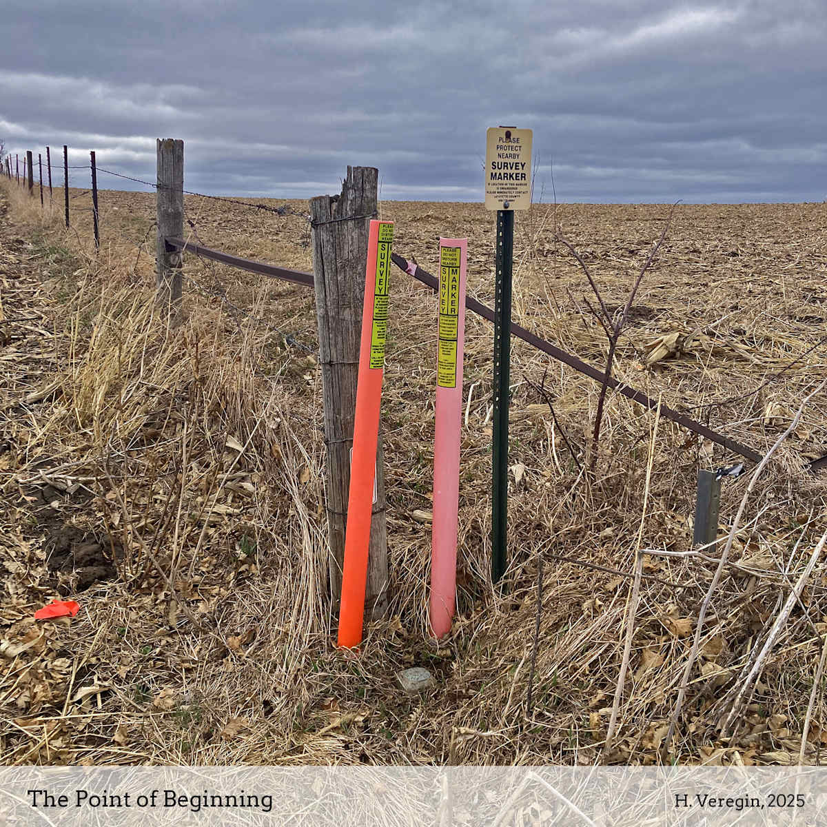
The reality is more mundane, although still quite fascinating. Wisconsin’s Point of Beginning is located along a rough dirt road straddling the Illinois border, about a half-mile east of Highway 80 near Hazel Green. It’s not much to look at – just a brass marker embedded in concrete, with several signs close by instructing who to call if the marker is disturbed or damaged.
The Point of Beginning is the origin point for Wisconsin’s Public Land Survey System, or PLSS. The PLSS is the rectangular system of one-mile by one-mile tracts of land (called sections) that cover almost every inch of the state. These sections are grouped into blocks called townships, 6 miles by 6 miles in size, each containing 36 sections. From the Illinois border north to the Apostle Islands, Wisconsin has 53 townships. From west to east, there are 50 townships. The Point of Beginning sits on a line of longitude called the 4th Principal Meridian, which divides Wisconsin’s townships into two ranges, one eastern and one western.
The PLSS was a product of the Enlightenment Era. Conceived after the Revolutionary War, it was codified by the Land Ordinance Act of 1785 to provide for the orderly conveyance of federal land to states and private citizens. This had the combined effect of encouraging settlement of the frontier to establish US title to these areas, providing revenue to the federal government through land sales, and granting land to Revolutionary War veterans as a way of paying them for their service. First implemented in Ohio, the PLSS was eventually adopted in thirty states.
In Wisconsin, the PLSS originates at the Point of Beginning. All legal descriptions of PLSS land tracts ultimately refer back to this point. The location was fixed in 1831 by a surveyor named Lucius Lyon, who had been appointed to survey the baseline between Illinois and that part of Michigan Territory lying west of the Great Lakes. Today this baseline is the Wisconsin-Illinois border. It was supposed to follow the line of latitude at 42 degrees 30 minutes north, but due to the limited capabilities of surveying equipment in use at the time, the line wobbles significantly.
Based on modern understanding of the earth’s shape, the Point of Beginning is not even located at 42 degrees 30 minutes, but a half-mile north of that line. But it is the physical monument – the brass marker set in concrete – that legally defines the location of the Point of Beginning, not the location it is, in theory, supposed to occupy.
In 1831, Lyon and his crew began surveying the baseline at the Mississippi River, and then headed east. When they reached the 4th Principal Meridian, they demarcated the Point of Beginning with a large mound of dirt. They returned to the spot in 1833 to complete the baseline survey. In his field notes from that year, Lyon refers to the Point of Beginning as a “large mound raised at the intersection of this line [the baseline] with the 4 Principal Meridian.” Over time, more permanent markers were established, culminating in the brass marker set in concrete that can be seen today.
The unyielding geometric character of the PLSS has a significant impact on how the rural landscape is experienced and understood. The regular pattern of one-mile sections dictates rural settlement patterns, the size and boundaries of farm fields, the locations of roads and highways, and even the boundaries of towns and counties. Wisconsin’s rectilinear landscape stands in contrast to the organic settlement patterns in the states of New England and the eastern seaboard, which were settled before the PLSS was adopted, and which rely on an older metes and bounds survey system based on local landmarks rather than straight lines.
Wisconsin’s Point of Beginning may not be the nucleus of the Big Bang that created the universe, but it was the epicenter of a different kind of explosion whose shock waves spread across the state. The PLSS opened Wisconsin to European settlement on a large scale, conveying ownership to blocks of land based on a geometric logic that ignored, not only physical geography, but the historic land use practices of Native Americans, who had inhabited the area for millennia. Between 1831, when Lyon established the Point of Beginning, and 1866, when the PLSS had been extended across Wisconsin, the population of the state grew by almost a million people.