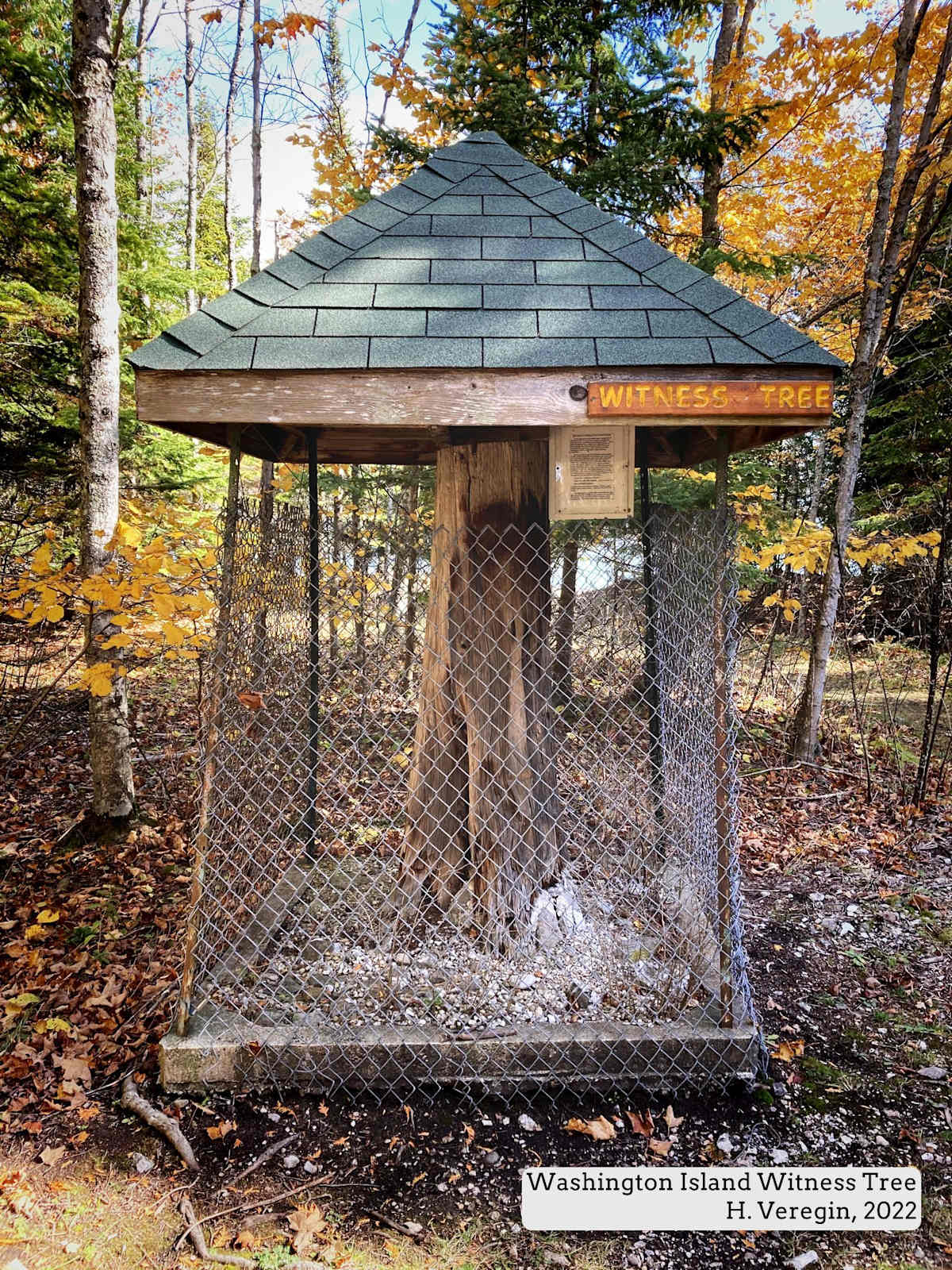
It’s a few hundred feet from the Lake Michigan shoreline on the east side of Washington Island in Door County. It’s the trunk of a long-dead tree. It sits on a crumbling concrete foundation, surrounded by a wire fence and capped with a roof to keep off the rain and snow. A monument to a tree? [1]
A plaque nearby says it’s a witness tree, one of thousands designated in Wisconsin (and other states) in the nineteenth century to demarcate the Public Land Survey System (PLSS). Conceived by President Jefferson, the PLSS divided lands recently acquired by the federal government into an orderly checkerboard of six-mile by six-mile squares called townships. Townships were in turn divided into thirty-six one-mile by one-mile sections, each comprised of four quarter-sections. [2] As described in Oddsconsin 12, the surveying process in Wisconsin began in the 1830s at the Illinois border. Over the next thirty years, it proceeded through the rest of the state. The delineated PLSS lands were sold to private citizens to raise revenue for the federal government and to promote settlement of the western frontier.
How do witness trees factor into this effort? To document and map the rectangular PLSS network, surveying crews set markers, called monuments, at every quarter-section corner – some 150,000 monuments in total, usually just wooden posts. To enable rediscovery of PLSS corners if the posts were lost or damaged, surveyors identified nearby trees, documenting their locations, species and size. These were called witness trees or bearing trees.
Almost a half-million individual witness trees were documented across the state. Each one is recorded – in cursive script – in surveyors’ notebooks that have been preserved, scanned and made available online [3]. The Washington Island Witness Tree is a case in point. The tree was documented in March, 1835, by a crew led by Deputy Surveyor Sylvester Sibley traversing the southern edge of Township 34 North, Range 30 East. At the corner of Sections 33 and 34, Sibley set a post and selected two witness trees, a Spruce with a diameter of 8 inches and a White Pine with a diameter of 22 inches – the Washington Island Witness Tree. [4]
Surveyors documented trees at PLSS corners and also along the lines connecting these corners. On the south edge of Section 33, Sibley recorded the locations of a Beech (14 inches in diameter) and an Aspen (also 14 inches in diameter). The crew set a wooden post at the quarter-section corner a half-mile to the west of the Washington Island Witness Tree and selected two Spruce trees – one 7 inches in diameter and one 14 – as witness trees for this corner. Sibley made an observation that the trees in the area were mostly Sugar Maple, Aspen, Cedar and Spruce. The White Pine seems to have been an exception to the overall pattern.
The surveyors’ notebooks make it possible to travel back in time to explore the trees that existed in the state nearly two hundred years ago. For example, The Wisconsin State Capitol in Madison is at the corner of Sections 13, 14, 23 and 24 of Township 7 North, Range 9 East. In 1834, surveyors set a monument there and selected two witness trees, one Black Oak with a diameter of 7 inches and one Burr Oak with a diameter of 20 inches. [5] A Burr Oak that large could have been almost 130 years old at the time, which means it was a seedling in about 1700. [6] Of course, the tree no longer exists, since this location is now at the center of the Capitol rotunda.
If it were not for the surveyors’ notebooks, we would have no record of the trees that stood in Wisconsin before European settlement modified the landscape through logging and agricultural activities. Most witness trees are long dead, although a few survive to this day. [7]
But there’s even more value in these notebooks. Researchers in Wisconsin have transcribed them to create a digital database of witness tree locations and information. This work was carried out at UW-Madison’s Forest Ecosystem and Landscape Ecology Lab in the Department of Forest and Wildlife Ecology, under the direction of (now Emeritus) Professor David Mladenoff. For mapping professionals, the database can be used to perform analyses and make maps of historic vegetation patterns. [8]
An example is a mid-1800s land cover map showing native vegetation prior to permanent European settlement. [9] The map shows the dominant and most abundant tree species. Ecological regions are clearly visible, such as the Pine Barrens in northwest Wisconsin and the extensive Oak Savannahs of southern Wisconsin and the Driftless Area. Comparing this map to a modern map of land cover reveals the changes that have occurred over time, the ecosystems that have been lost and remaining fragments of old-growth forest. Such comparisons are of immense value to ecologists, foresters, planners and land managers.
Using the data comes with many caveats, since the PLSS surveys extended over decades and employed over a hundred different surveyors, each with different abilities to identify tree species. Procedures for recording trees also changed over time. [10]
The Washington Island Witness Tree is an important symbol reminding us that the landscapes of Wisconsin were – only a few centuries ago – very different than they are today. Without the witness trees of the PLSS survey, we would not be able to understand these changes in detail. The irony here is clearly visible, since it was the PLSS survey itself that ushered in these changes by opening the state to settlement.
Sources and Notes
[1] The tree is on a small right of way between two privately owned parcels.
[2] Board of Commissioners of Public Lands and UW-Madison Libraries, Land Survey Information. https://digicoll.library.wisc.edu/SurveyNotes/SurveyInfo.html
[3] Board of Commissioners of Public Lands and UW-Madison Libraries, Wisconsin Public Land Survey Records: Original Field Notes and Plat Maps. https://digicoll.library.wisc.edu/SurveyNotes/
[4] Board of Commissioners of Public Lands and UW-Madison Libraries, Section Line, Township 34 North, Range 30 East, Section 33, South boundary (East). https://digicoll.library.wisc.edu/cgi-bin/SurveyNotes/SurveyNotes-idx?type=article&byte=1443385&isize=L&twp=T034NR030E
[5] Board of Commissioners of Public Lands and UW-Madison Libraries, Section Line, Township 7 North, Range 9 East, Between Sections 13 and 24 (East). https://digicoll.library.wisc.edu/cgi-bin/SurveyNotes/SurveyNotes-idx?type=article&byte=29633739&isize=L&twp=T007NR009E
[6] The Land Conservancy of McHenry County, How old is that Oak? https://conservemc.org/how-old-is-that-oak/
[7] Eugenie Huang, Experience the New Wisconsin Bearing Trees. https://www.sco.wisc.edu/2025/05/08/experience-the-new-wisconsin-bearing-trees/
[8] Forest Landscape Ecology Lab and Wisconsin State Cartographer’s Office, Original Public Land Survey Records (WIGLOSR). https://www.sco.wisc.edu/glo/
[9] David Mladenoff, Wisconsin's Land Cover in the Mid-1800s. [Department of Natural Resources copy.] https://p.widencdn.net/wtnbbf/Map_S4_GLO_LandCover
[10] Forest Landscape Ecology Lab and Wisconsin State Cartographer’s Office, Wisconsin General Land Office Survey Records (WIGLOSR) Database Documentation v. 4. https://www.sco.wisc.edu/wp-content/uploads/2020/10/WIGLOSR_Database_Documentation_20.10.pdf