Does Wisconsin have a lot of churches? The GNIS (Geographic Names Information System), the official federal repository of geographic feature names, listed 3,578 of them in 2021. [1] That’s fifty churches per county, or one for every 1,650 people.
Churches have since been removed from GNIS, due to the cost of keeping the listing current. Determining the exact number of churches is complicated. In the 2020 US Religion Census, a “church” is not necessarily a single building, but a religious body that may have multiple congregations, which may in turn be parishes, churches, temples, mosques or other sites with regular worship services. [2]
Many of Wisconsin’s church buildings are found in rural communities, where there was once a population large enough to support large congregations. These churches, often massive stone and brick structures, are monuments to the past, testifying to the beliefs of early settlers that their communities would be permanent, not transitory.
Some notable examples are the twin East and West Koshkonong Norwegian Lutheran Churches in eastern Dane County, St. Casimir Church (along with a rectory and school) northwest of Stevens Point in Portage County, and the sprawling St. Ambrose campus (church, seminary and school) near St. Nazianz in Manitowoc County.
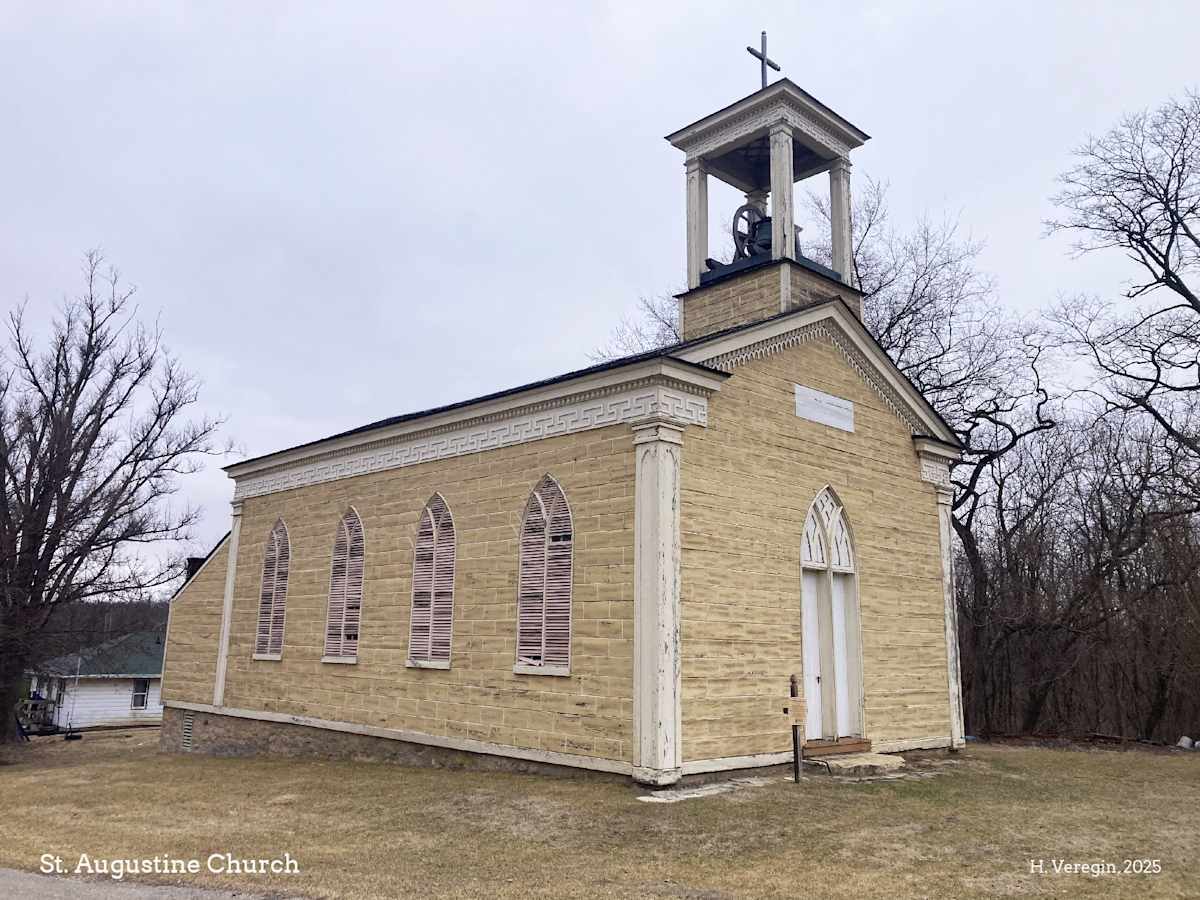
St. Augustine Church, in the unincorporated community of New Diggings in southwest Lafayette County, is remarkable for its age and construction. Built in 1844-47 for the Irish families in the area, it is nearly two hundred years old. When the church was built, Wisconsin was not yet a state, and the Public Land Survey System, which ultimately divided Wisconsin into one-mile by one-mile blocks of land to enable private ownership, had just been initiated at a point a few miles to the west. [3]
St. Augustine Church appears to be made of stone, but it is actually a wood frame building. It is covered with wooden planks that were cut and painted to resemble limestone. The church was built in a combination of Gothic and Greek Revival styles, with an ornamented gable, a Greek key frieze and gothic arch doors and windows. Its bell was made in a foundry in New York state and installed in 1847. The church was placed in the National Register of Historic Places in 1972. [4]
The church faces an empty parcel of land with a gravel roundabout. Historic air photos show that, until at least the 1960s, there was a two-story building here, possibly a school. There was also a large shed or barn. These buildings are no longer in existence. [5]
St. Augustine Church was designed and built by a priest, Father Samuel Mazzuchelli, an Italian Dominican missionary who built as many as twenty-five churches in southwest Wisconsin, northwest Illinois and northeast Iowa. St. Augustine is the only known Mazzuchelli church that has undergone no alteration. In the early 1960s, members of the Knights of Columbus restored the church, replacing deteriorated wood, rebuilding the foundation and repairing the bell tower. The restoration was faithful to the original design. [4]
Mazzuchelli came to the United States in 1828, at the age of twenty-two. In 1847, he established a community of Dominican Sisters in Sinsinawa [6] fifteen miles west of New Diggings. The Sinsinawa Congregation is still active, with over twenty Sisters living at the Mother House. [7] St. Augustine Church once had a classroom in its basement where Sisters from Sinsinawa ran a Sunday School.
As its name suggests, New Diggings was a mining community. Lead was the primary mineral mined here. This part of the state was settled by European immigrants from Ireland, Wales, Cornwall (England) and elsewhere. The Wisconsin Historical Society site at Pendarvis in Mineral Point (Iowa County) preserves the Cornish history of this part of the state. [8] The painted planks covering St. Augustine Church echo the stone used for the buildings at Pendarvis.
Much of the land to the south and west of New Diggings is owned by the Champion Mining Company. Less than a mile to the west is the old Champion Mine, which was in operation until about 1946. [9]
The mining activities in the area also explain why Wisconsin is known as the Badger State. The area was settled comparatively early by Europeans, who were attracted by its mineral richness. The European-born population grew rapidly before the time of statehood in 1848, after Native Americans were forced to cede their land. The name badger was applied to miners who lived in their mines and pits, like badgers in their burrows. [10]
The name New Diggings was apparently bestowed as early as 1824 by miners from Galena, Illinois. A post office was established in 1844. Other communities in the area, no longer in existence, took similar names, including Irish Digs and Hardscrabble Digs. [11] An unincorporated community known as Lead Mine still exists a few miles to the north.
As an unincorporated community, New Diggings is neither a city nor a village. Legally, it is part of the Town of New Diggings. The community has no boundaries, no city council and its population is not tracked by the US Bureau of the Census. There are hundreds of unincorporated communities in the state, some with green Unincorporated signs and some without. [12] Over time, many of these communities have disappeared, but New Diggings is still around, with houses, a general store, a tavern and several churches, including St. Augustine.
Sources:
[1] US Geological Survey, Geographic Names Information System (GNIS). https://www.usgs.gov/tools/geographic-names-information-system-gnis
[2] Association of Statisticians of American Religious Bodies (ASARB), The Association of Religion Data Archives (ARDA) and Lilly Endowment, 2020 US Religion Census. https://www.usreligioncensus.org/
[3] Oddsconsin 12 – The Point of Beginning. https://howard-veregin.com/blog/oddsconsin-12-the-point-of-beginning-oddsconsin-where-we-explore
[4] National Register of Historic Places, St. Augustine Church. https://npgallery.nps.gov/GetAsset/5d6f03a2-b39f-44c2-a627-bd0a626a06d7
[5] State Cartographer’s Office and Robinson Map Library, Wisconsin Historic Aerial Imagery Finder (WHAIFinder). https://maps.sco.wisc.edu/whaifinder
[6] Jackie Johnson, MissPronouncer. https://misspronouncer.com
[7] Sinsinawa Dominican Sisters. https://www.sinsinawa.org/
[8] Wisconsin Historical Society, Pendarvis. https://pendarvis.wisconsinhistory.org/
[9] mindat.org, Champion and Eureka Mine. https://www.mindat.org/loc-169364.html
[10] Wisconsin Historical Society, Badger History: Why Are We the Badger State? https://wisconsinhistory.org/Records/Article/CS16342]
[11] Edward Callary, Place Names of Wisconsin, University of Wisconsin Press, 2016.
[12] State Cartographer’s Office, Wisconsin’s Hidden Communities. http://go.wisc.edu/hidden-communities