Archaedromosology is a portmanteau [a word made by combining two or more other words] referencing the study of ancient pathways and routes. The prefix comes from the Greek arkhaios (ancient), combined with dromos (road) and -ology (the study of). It generally describes the archaeological and historical study of ancient roads, trade networks and infrastructure.
- Google AI Overview
The next time you’re in Waukesha County, take a minute to pay homage to the oldest stretch of Interstate Highway in the state.
The 7.5-mile section of I-94 between County Highway SS (Exit 290) and Goerke’s Corners (US Highway 18/State Highway 164, Exit 297) was completed in 1958, almost seventy years ago. [1] It was the first piece of Wisconsin’s Interstate System – a small section of rural highway selected to showcase the system’s new features and demonstrate proof-of-concept.
Official highway maps produced by the Wisconsin Department of Transportation (WisDOT) show the evolution of the Interstate System over time. [2] Interstates first appear on the 1960 map, including a section of I-94 from the Illinois border near Pleasant Prairie to Milwaukee (dedicated on December 3, 1959) and a section of I-94 from the Minnesota border near Hudson to Eau Claire (dedicated on October 29, 1959).
The Waukesha County section of I-94 (dedicated on September 4, 1958) appears on WisDOT maps as US Highway 16/18 and State Highway 30 until 1964, when other portions of I-94 were completed. When the final segment of I-94 – between Black River Falls and Tomah – opened in 1969, the highway stretched from Minnesota to Illinois. Interstate construction in the state continued over the decades, with the additions of I-90, I-43, I-39, I-41 and several Auxiliary Highways.
Not everyone was happy with the way Wisconsin’s Interstate System evolved. Gaylord Nelson, running (successfully) for governor in 1958, argued that Republican governor Vernon Thompson “sold out the entire northern half of Wisconsin by refusing to fight for our fair share of four-lane Interstate highways.” Nelson compared Wisconsin’s Interstate System to those of Minnesota and Michigan, arguing that in those states, the four-lane highways went “right to the heart of their northern vacationlands.” [3]
Planning for high-speed, limited-access freeways in Wisconsin began in the 1940s after World War II, as automobile ownership increased and planners recognized the need for a more modern transportation system. At the federal level, the idea for an Interstate System goes back to the 1930s. But it was the Federal-Aid Highway Act of 1956 that formalized the system and established a mechanism to fund it. Under the Act, the federal government covered 90 percent of the cost of Interstate construction, with the state providing 10 percent. The federal contribution was supported in part by an increase in the federal gasoline tax.
One of the recurring myths about the Interstate System is that it was built primarily for military purposes, including troop movements, evacuation of urban areas in the event of an atomic attack, and take-offs and landings of military aircraft. Google’s AI Overview tells us that “national defense was a primary motivator for the system…it was designed to quickly mobilize troops, transport heavy military equipment, and serve as evacuation routes during the Cold War.”
But the US Department of Transportation’s Federal Highway Administration – an authority on the Interstate System if there ever was one – disagrees, stating that the “primary justifications for the Interstate System were civilian in nature” including “economic development, improved highway safety, and congestion relief, as well as reduction of motor vehicle-related lawsuits.” [4] The military benefits of the system were recognized, but not the sine qua non of its development.
Most of us take the Interstate System for granted. But in the late 1950s, many drivers had seen nothing like it before. The Kenosha Evening News, on July 24, 1958, described the Waukesha portion of I-94 – still under construction at the time – as “not just another road” but rather as a “revolution” in transportation. [5] The overall impression of the new highway was “one of immense size” with travel pushed into “completely new dimensions.” The reader is asked to imagine driving at seventy miles per hour, with no stop lights, along a straight, uninterrupted roadway, with vehicles entering via modern “clover leaf” and “trumpet” interchanges.
The Interstate offered speed, efficiency and safety. It was a showcase of modern engineering and technology. It pointed to a bright future – like the world of the cartoon Jetson family, with gleaming homes high above the clouds, food-dispensing machines, helpful robots and flying cars.
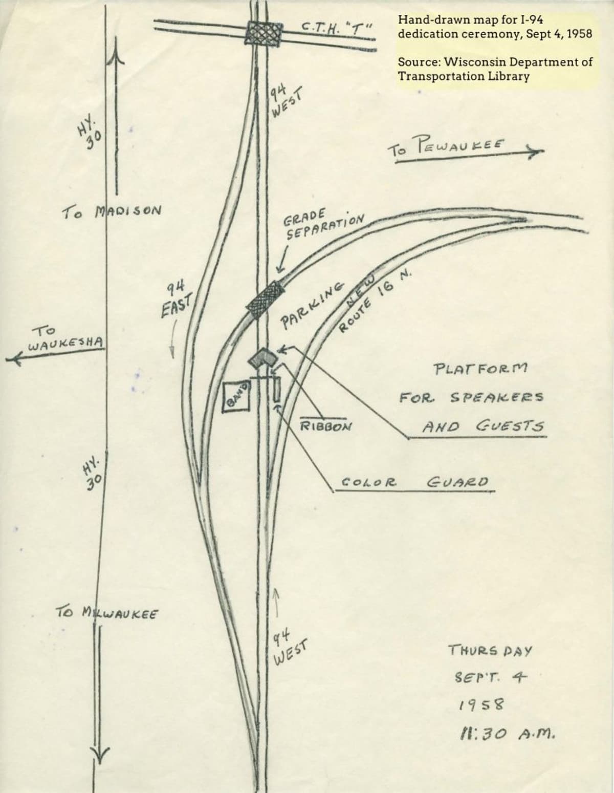
The section of I-94 in Waukesha County was dedicated on September 4, 1958. The invitation for the event – the “Official Opening of the First Completed Section of Wisconsin’s Interstate Route 94 in Waukesha County” – is quaint. The site map is hand-drawn. It shows the locations of the color guard, the band, parking and the platform for speakers and guests. [6]
An account of the ceremony appears in the Wisconsin State Journal on September 5, 1958. [7] Attending the ribbon-cutting were various dignitaries – a county board chair, a mayor, a member of the state assembly, a state senator, the secretary of state … and Governor Vernon Thompson. Thompson made a speech focusing on how the Interstate System would support commerce, agriculture and industry, including tourism and the resort business.
At the ceremony, five-year-old Tommy Crouch of Pewaukee made an offering to Governor Thompson – a package of pebbles. (Perhaps these represented the gravel of the roadbed?) Also at the ribbon-cutting were Miss Concrete and Miss Black Top, the honorary titles emblazoned on sashes draped over their ball gowns. The governor cut the ribbon with a large pair of scissors and a new age of transportation in Wisconsin began.
The ribbon-cutting ended with a luncheon at Aliota's, a supper club and piano bar on Blue Mound Road in Waukesha.
You can visit the location of the ribbon-cutting ceremony today at 43°02'51" N, 88°14'50" W. But it would be difficult to get a photograph as the location is in the middle of the westbound lanes of I-94. The roadway has widened over the years – three lanes now, not just two – and some of the interchanges have been modified, but the overall impression is the same. There really ought to be a historic marker here.
Sources
[1] Christopher J. Bessert, Wisconsin's Interstates, Wisconsin Highways Website. https://www.wisconsinhighways.org/interstates.html
[2] Wisconsin Department of Transportation, Historic Maps. https://wisconsindot.gov/pages/travel/road/hwy-maps/default.aspx
[3] Nelson on the North, Wisconsin State Journal, Sept. 21, 1958, p. 21.
[4] Federal Highway Administration, US Department of Transportation, Interstate Highway System - The Myths. https://highways.dot.gov/highway-history/interstate-system/50th-anniversary/interstate-highway-system-myths
[5] Vast Road-Building Program Changes Area Travel Picture, The Kenosha Evening News, July 24, 1958, p. 1 and 10.
[6] Wisconsin Department of Transportation Library, Highway Dedication Programs - Interstate 94 - Waukesha County - September 4, 1958. https://content.mpl.org/digital/collection/WDTL/id/1290/
[7] Governor Opens First Interstate Highway Section. Wisconsin State Journal, Sept. 5, 1958, p. 9.