History is not contained in thick books but lives in our very blood.
- Carl Jung
This is the third and final post in a series on fatal airplane accidents in Wisconsin. [Read Part 1 and Part 2.]
The deadliest military airplane accident in Wisconsin occurred on November 18, 1966, when a B-52 bomber crashed fifteen miles south of Hayward, in Sawyer County, killing all nine crew members.
The bomber was on a ten-hour training mission from Barksdale Air Force Base in Shreveport, Louisiana, and had just refueled in flight. [1] Witnesses reported that the airplane exploded at about 6:30 pm as it crashed into a densely wooded area. [2] The huge eight-engine airplane disintegrated on impact.
In the 1960s, B-52s played a role in the Vietnam War, where they were used as heavy bombers. But the Sawyer County B-52 was not training for Vietnam. Barksdale Air Force Base (AFB) was part of the US Strategic Air Command (SAC), which operated during the Cold War to support the country’s nuclear deterrence force. [3]
The SAC’s B-52 bombers were capable of dropping nuclear bombs on distant targets, such as enemy military bases and nuclear missile sites. With the aid of air refueling tankers the bombers would have been able to fly from Shreveport to any of a number of military sites in the USSR following the shortest route across the Arctic Ocean. [4]
Newspaper reports indicate that the bomber was on a simulated bombing run over the USSR when it crashed. [5] The crew was conducting a low-altitude test of a new ground reconnaissance radar. [6] Stealth technology had not yet been developed and low-level flying was used to slip in undetected past enemy radar coverage.
The site of the crash was investigated by teams from Barksdale AFB, K. I. Sawyer AFB in Michigan and Duluth AFB in Minnesota. [2] But after the site was cleared, it fell into obscurity. In 2016, Tom Sybert, who grew up in Chicago, began investigating the crash with the goal of commemorating its 50th anniversary. Sybert’s great uncle witnessed the crash and, as a boy, Sybert vacationed in the area and recalled seeing artifacts that local residents had discovered. [7]
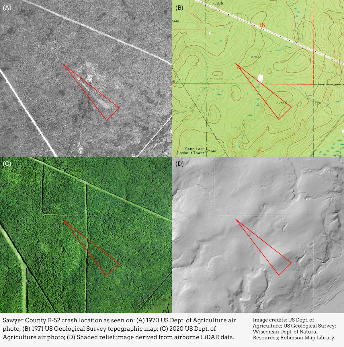
But Sybert couldn't find anyone who remembered exactly where the B-52 hit the ground. After contacting the Air Force without much success [5], he called Jaime Martindale, Distinguished Map and Geospatial Data Librarian at the Robinson Map Library at UW-Madison. [8] Sybert wondered if a crash scar might be visible on historic aerial photographs. The Map Library is home to the largest collection of historic aerial photos of Wisconsin, with over 260,000 images in the archive.
When Martindale learned that the bomber was on a low-altitude mission, she consulted topographic maps, looking for hills the airplane might have hit. [9] She then cross-referenced these locations against historic aerial photos and soon found the crash scar on a black and white photo from 1970. The scar was a wedge-shaped gash over a mile long intersecting the area’s hilly terrain.
With the information Martindale provided, Sybert worked with local residents, the Lac Courte Oreilles Band of Lake Superior Ojibwe (the crash site is within the Lac Courte Oreilles Reservation) and the Stone Lake Historical Society to install a memorial. Sybert designed and built the memorial, which faces southeast toward the plane’s path. A memorial service was held, attended by local residents and family members of the crew. [5][10]
For Martindale, the discovery of the crash site underscores the value of the Robinson Map Library’s historic aerial photograph collection, saying, “It’s a great example of how these photos are useful in all sorts of unexpected ways, and explains why we need to preserve them and make them accessible to the public.” [11]
Without the Robinson Map Library, Sybert might never have found the crash site and provide an opportunity for remembrance and reflection for the family members of the airplane’s crew.
Sources and Notes:
[1] Wisconsin State Journal, Nov. 19, 1966, p. 1.
[2] Wisconsin State Journal, Nov. 20, 1966, p. 33.
[3] The B-52 bomber is still in use, and the Air Force has no plans to phase it out until the 2050s, a century after its initial deployment. Barksdale AFB is still home to much of the military’s B-52 fleet, now under the Air Force’s Global Strike Command. See: US Air Force, B-52H Stratofortress. https://www.af.mil/About-Us/Fact-Sheets/Display/Article/104465/b-52h-stratofortress/
[4] The opening sequence of Stanley Kubrick’s 1964 film, Dr. Strangelove, depicts a B-52 being refueled in flight.
[5] Regan Kohler, Illinois man recognizes those killed in Stone Lake B-52 crash in 1966, Sawyer County Record, July 20, 2107. https://www.apg-wi.com/sawyer_county_record/paywall/illinois-man-recognizes-those-killed-in-stone-lake-b-52-crash-in-1966/article_438c6fae-6c8a-11e7-ba77-03545f53399d.html
[6] Bureau of Aircraft Accidents Archive, Crash of a Boeing B-52G-105-BW Stratofortress near Stone Lake: 9 killed. https://www.baaa-acro.com/crash/crash-boeing-b-52g-105-bw-stratofortress-near-stone-lake-9-killed
[7] Meg Jones, Map librarian finds 1966 crash site, Milwaukee Journal Sentinel, Aug. 29, 2016. https://www.jsonline.com/story/news/local/2016/08/29/map-librarian-finds-1966-crash-site/89303126/
[8] The Arthur H. Robinson Map Library. https://geography.wisc.edu/maplibrary/
[9] Chris Barncard, UW–Madison map library pinpoints Sawyer County site of 1966 bomber crash, University of Wisconsin-Madison. https://news.wisc.edu/uw-madison-map-library-pinpoints-sawyer-county-site-of-1966-bomber-crash/
[10] B-52 accidents have claimed the lives of at least 367 people in Arizona, California, Canada, Colorado, Diego Garcia, Florida, Greenland, Guam, Japan, Kansas, Laos, Maine, Maryland, Michigan, Minnesota, Mississippi, Montana, Nevada, New Mexico, North Carolina, North Dakota, Oklahoma, Oregon, Puerto Rico, South Carolina, South Dakota, Spain, Thailand, Utah, Vermont, Vietnam, Washington and Wisconsin. https://www.hulk46.org/501-2/
[11] Two Robinson Map Library online resources that can be used to find historic aerial photographs of Wisconsin are the Aerial Photography Catalog and the Wisconsin Historic Aerial Image Finder.