Wisconsin is geographically unique. It’s the only state that contains the point at 45 degrees north latitude, 90 degrees west longitude, marking the center of both the Northern and Western Hemispheres. But where, exactly, is it?
There’s a geographical marker in Marathon County known is the “Poniatowski Marker" that claims to be this point. The marker states that the location is (a) midway between the Equator (the baseline for latitude, at 0 degrees) and the North Pole (at 90 degrees north) and (b) midway between the Prime Meridian (the baseline for longitude at 0 degrees, running through Greenwich, England) and 180 degrees west longitude, which is in the Pacific Ocean on the opposite side of the earth from Greenwich. [1]
Unfortunately, these statements are not quite true. The location of 45 degrees north, 90 degrees west exists somewhere in the state, but not here.
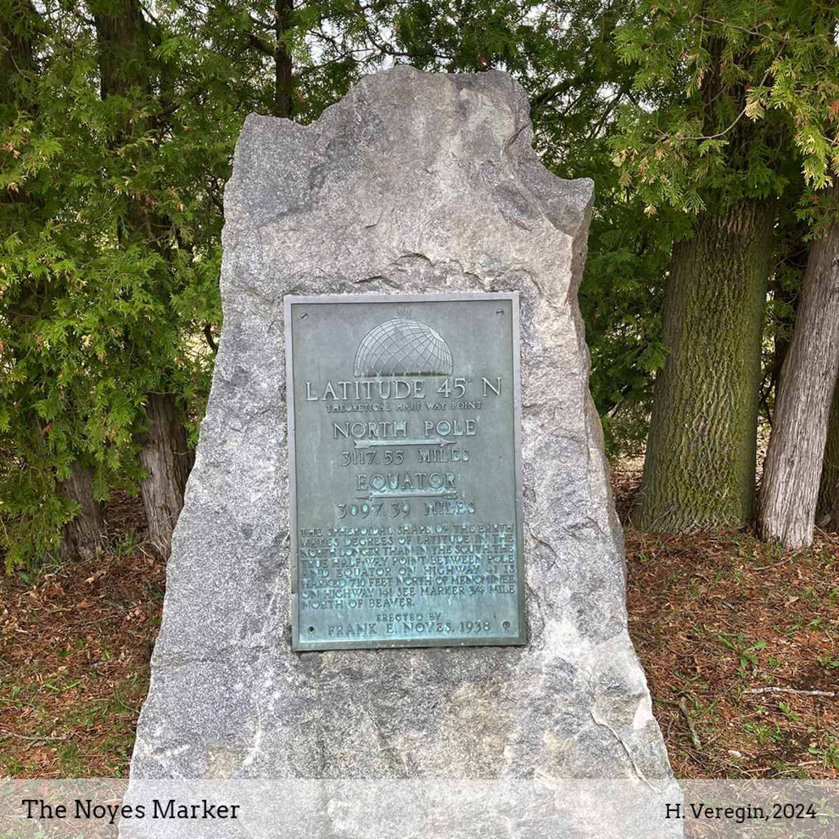
Other geographical markers in Wisconsin make similar claims. The one shown in the photograph is in southern Marinette County off Highway 41. The marker was set in 1938 by Frank E. Noyes, publisher of the Marinette Eagle. The Noyes Marker states that it is located at 45 degrees north, the “theoretical half way point” between the Equator and the North Pole. However, it then contradicts itself by giving the distance to the North Pole as 3,117.55 miles and the distance to the Equator as only 3,097.39 miles.
The reason for this contradiction is that the earth is not a perfect sphere. Rather, its shape is better approximated by an ellipsoid, sometimes called an oblate spheroid. The earth bulges out at the Equator. It’s shaped like a beach ball that someone is using for a chair.
The exact equatorial radius of the ellipsoid (distance from the Equator to the center of the earth) is a matter of debate, but we can use 3,963 miles as an approximation. In comparison, the polar radius (distance from the North or South Pole to the center of the earth) is only 3,950 miles. That’s only a 13-mile difference, but it’s big enough to cause the discrepancies seen on the Noyes Marker.
Due to the earth’s ellipsoidal shape, lines of latitude widen as you move north from the Equator. For example, at 20 degrees north, a degree of latitude is about 68.8 miles wide, while at 70 degrees north, it is about 69.3 miles wide. Therefore, at 45 degrees north, you are in fact closer to the Equator than the North Pole.
However, there’s more to the story, because the Noyes Marker is not at 45 degrees north. It was at one time, but not any longer. This is not due to plate tectonics (that will be discussed later) but the adoption of a new ellipsoid decades after the marker was set.
An ellipsoid is only a rough approximation of the actual shape and size of the earth, and hundreds of different ellipsoids have been proposed and used throughout history. In the United States, we can narrow these down to three main ones: the Clarke 1866 Ellipsoid (used until 1983), GRS80 (used in civilian mapping today), and WGS84 (used today by the military and in GPS). [2]
Put simply, the location of 45 degrees north, 90 degrees west (or any other point for that matter) is at a physically different location depending on the ellipsoid used. The Noyes Marker may have been at 45 degrees north in 1938, based on the Clarke 1866 ellipsoid, but on the WGS84 ellipsoid, the location of 45 degrees north is over 400 feet to the north.
It can be a bit disturbing to realize that any pair of latitude-longitude coordinates does not represent a fixed location, but rather a location that varies depending on the ellipsoid used. This means that every time Geodesists – scientists who are concerned with the size and shape of the earth – adopt a new ellipsoid or make an adjustment to an existing one, the latitude and longitude of every point on the earth changes. If we wanted the Noyes Marker to be accurately located, we would need to pick it up and move it every few years. But of course, since multiple ellipsoids are currently in use (such as GRS80 and WGS84) we would never be able to find a location acceptable to everyone.
There is a final wrinkle to the story. Due to plate tectonics, all locations on the earth are physically moving, as a result of the rotation of crustal plates (on which we live) over the semi-molten mantle that circulates through the interior of the earth. Wisconsin is rotating in a counter-clockwise direction at a rate of just under an inch per year. The Noyes Marker has therefore moved about 2.5 feet in the 87 years since its construction.
The newest geodetic models of the earth incorporate tectonic movement by explicitly accounting for time. The location of a latitude-longitude coordinate pair is therefore dependent, not just on the ellipsoid, but also on the date.
If this all makes you feel a bit unsettled, as if the earth was literally shifting under your feet, you would not be alone. It’s a bit reminiscent of the poem, The Second Coming, written in 1919 by W. B. Yeats.
Things fall apart; the centre cannot hold;
Mere anarchy is loosed upon the world.
What’s making it possible for such hyper-accurate measurements of tectonic movement and the earth’s ellipsoid? Technology, of course. It seems that the price we pay for scientific advancement is a sense of instability.
As to why such high accuracy is needed, the answer again is technology. If you imagine a future in which cars drive themselves while their human passengers relax watching TikTok videos, a few feet of error in location can be significant.
No geographical marker can ever claim to be at 45 degrees north and exactly halfway between the North Pole and the Equator. At least, not without bending the truth. And it’s probably in the wrong spot anyway.
Sources and Notes:
[1] Historical Marker Database, Geological Marker. https://www.hmdb.org/m.asp?m=128787
[2] GPS stands for Global Positioning System, the military satellite system that controls the blue dot on your iPhone map. This is why latitude-longitude coordinates (like 45 degrees north, 90 degrees west) are sometimes called GPS coordinates.